
 Connect with Facebook


| Elevation: | 4,314 ft |
| GPS: |
42.6752, -112.99824 Google Map · Climbing Area Map |
| Page Views: | 331,466 total · 1,667/month |
| Shared By: | Andy Laakmann on Nov 13, 2006 |
| Admins: | Eric Bluemn, Mike Engle |
 Access Issue: Use BLM route to access Massacre, see driving directions on the main page below. DO NOT TRESPASS ON PRIVATE 'SHORT CUT' FARM ROADS!! The land owners are asking climbers be respectful and not trespass on their private property.
Details
Access Issue: Use BLM route to access Massacre, see driving directions on the main page below. DO NOT TRESPASS ON PRIVATE 'SHORT CUT' FARM ROADS!! The land owners are asking climbers be respectful and not trespass on their private property.
Details
Description

Massacre Rocks is a large natural area of sagebrush, ancient cedar trees, sand dunes, and box canyons sculpted by the Great Bonneville flood some 14,000 years ago. The flood carved numerous natural box canyons and 'alcoves' leaving steep rock walls ranging from 30' to 200' in height. The exposed basalt formations were originally formed from repeated volcanic activity in the Snake River Plain. The rock is high quality black, brown, and tan basalt. It is steep (sometimes overhanging) and heavily featured with edges, pockets, blocks, slopers, bulges, dihedrals, and cracks - perfect for much varied sport climbing.
CULTURAL RESOURCE AWARENESS:
Massacre Rocks is part of the much larger “American Falls Archaeological District” (AFAD). mountainproject.com/v/11224… There are multiple land jurisdictions in both the AFAD and where climbing takes place (see BLM Map). Extensive and well documented studies of the AFAD near and around the Snake River show many cultural resources and evidence of human habitation for at least the last 13,000 years. This area is considered sacred to the Shoshone peoples. Be respectful and minimize your footprint and impact in the area. Keep your staging area small and contained. Pick up and pack out your trash including tape, orange or banana peels, cigarette butts, etc. Prevent your dog from digging. Don’t start or make any fires, especially near the base of cliffs.
In an effort to respect the cultural resources and tribal concerns, several routes names in this guide were changed to honor a request to eliminate potentially offensive names.
Remember, as on any Federal land, damaging cultural resources is a felony and punishable by fines and imprisonment. Deception Cove is posted closed to climbing. Please respect this and any other closures. While nearly all the established climbing cliffs do not have known petroglyphs or pictographs, should you happen to find one, usually near ground level, cease climbing and notify the Bureau of Land Management at the Burley Field Office, 208 677 6600.
Also, please, only park in one of the designated parking areas and respect all road closures. Sandy soils in the AFAD are prone to wind erosion. Motorized vehicles and even foot traffic can damage the fragile ecology and could destroy rare, irreplaceable evidence of 13,000 years of human habitation. When hiking to the crags use established trails and don’t short cut or braid existing trails. See the graphic from the BLM to understand which areas are closed to motorized travel. mountainproject.com/v/11180…
ACCESS ISSUES:
Massacre rocks sport climbing area is not within the Massacre Rocks State Park boundaries (though there is fine documented bouldering within the state park). The crags reside on a combination of Idaho state land, Bureau of Reclamation (BOR) land, and Bureau of Land Management (BLM) land. In 2012 the BLM sought to limit or close climbing due to possible damage to cultural artifacts in the area. Ultimately, no action was taken and currently there are no restrictions on climbing on any of the Massacre Rocks land jurisdictions (as of April 2016). Many of the popular crags and climbs are on Idaho State Land where access was never threatened.
However, the BLM and BOR are collaborating to rollout a new management plan for the entire American Falls Archeological District by end of 2016 or early 2017. It is likely climbing will be impacted to some level. East Idaho Climber’s Coalition is working with the BLM and BOR to mitigate any issues and work towards a management plan that is most friendly to climbing. Stay tuned for public comment periods. Continuing to have a low impact footprint at Massacre can be a big help in the ongoing process. Be respectful, stay off private land, and be aware of cultural resource issues.
SPORT CLIMBING:
Massacre Rocks was one of the first modern climbing areas in the United States to fully embrace the sport climbing ethic. Most of the routes here were established in the 80's and 90's.
There are over 750 well equipped sport routes at Massacre on more than two dozen different walls ranging from 30' to 200' in height. The average climb is about 60'. The "climb anywhere" nature of the rock has led to a high concentration of routes on most walls. Sometimes routes are as close as 5 or 6 feet apart which can make identifying routes a challenge. A good strategy is to count bolts. Once a route has been identified, it's easy to track routes to the right or left. This guide and the free online guide have accurate bolt counts for most route descriptions.
The sport climbs at Massacre typically have closely spaced bolts for pushing your limits. Climbs range from 5.8 to 5.13 with most being in the middle of that range. If you climb 5.10 to 5.12 and like to clip bolts, you will find a nearly endless supply of high quality sport climbing.
GEAR:
A rack of up to 18 quick draws will suffice on the longer routes, while the majority of climbs take six to eight. There are some natural pro lines but they are seldom climbed. For these a standard rack of cams and nuts should do the trick.
SPORT ANCHORS:
The vast majority of routes have sport anchors which are typically an open cold shut and a steel or aluminum carabiner. This makes finishing and lowering from a route convenient. Please use your own gear if you plan to top rope the route. Occasionally, the routes will have chain anchors at the top of the climb, if in doubt always bring a couple extra draws.
ROPES/SAFETY:
Most climbs at Massacre allow a leader to be lowered using a single 60 meter rope however some longer routes may require two ropes. There have been lowering accidents at Massacre, so if you are not sure, tie a knot in the end of the rope so you don’t drop your partner, or even better, take two ropes. The Owl Cove, Main Wall Area, and Eagle Wall are places to watch out for two rope descents.
WEATHER/SEASONS:
The best climbing weather at Massacre is in the late fall and early spring although there are many very climbable days in the winter. Provided the sun is out, the dark rock and wind protected alcoves create micro-climates where it's possible to climb in t-shirts on 30 F winter days. These same features make climbing in the summer unbearably hot, though early morning or late evening outings on shady walls are possible.
CAMPING:
There is pleasant but primitive free camping at several locations near the parking on the west rim. Bring your own water, firewood and shovel.
HAZARDS:
There are rattlesnakes in the area though they are typically not a problem. If you bring dogs or children scope the area before settling down to climb.
It can be extremely hot at Massacre during the summer. The sand can burn bare feet. Dogs in particular can have a very tough time with the hot sand. Due to some long treks across hot sand, it is not advisable to bring dogs during summer, even if you intend to climb in the shade.
Getting There
Massacre Rocks is situated across the Snake River, northwest from Massacre Rocks State Park entrance fee station; the 200 foot Main Wall is visible from Interstate 86. Traditionally climbers accessed Main Wall and Owl Cove by taking a canoe across the Snake River. However the vast majority of the climbing is in box canyons and alcoves situated behind Owl Cove and Main Wall. For easier access to these walls climbers drive across the American Falls Reservoir Dam and follow paved roads to a public access dirt road. Three miles of two-track through BLM public land and state of Idaho public land lead to the parking areas along the west rims. From the the parking, some crags can be reached in as little as five minutes and the Main Wall is still only a 30 min hike through the back country.
DRIVING ACCESS:
Note that the last three miles is a two-track dirt road that requires moderate clearance. The two track While trucks and Subaru's have no problem and plenty of sedans (like Camrys and Accords) have made it too, be aware that clearance may be an issue.
From the town of American Falls, take State Highway 39 across the American Falls Reservoir dam. Take the first left turn onto the Lamb-Weston Road and set your trip odometer to zero.
* 0.0 miles: Left turn onto Lamb-Weston Road
* 0.2 miles: Turn left onto Borah Road
* 1.8 miles: Turn left onto the paved Lake Channel Road; it follows the river for awhile before heading across potato fields.
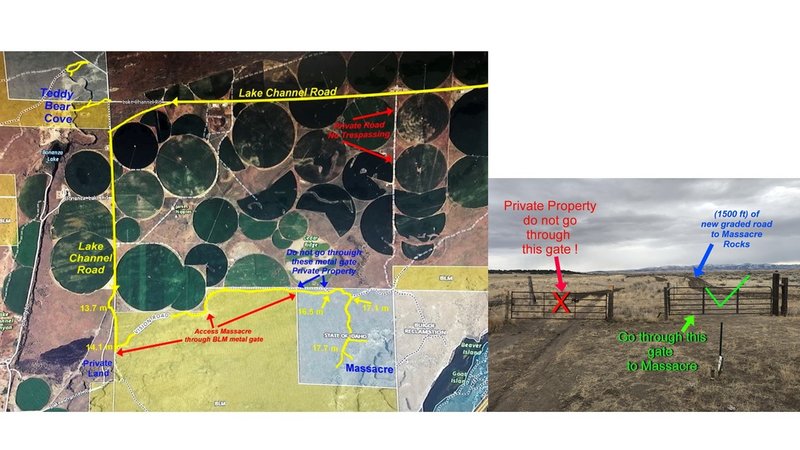
* 13.7 miles: Turn left onto a dirt two-track road. Follow this road for about 100 yards all the way to the fence line. A very short distance before the fence, you will cross a dirt road. DO NOT TURN RIGHT YET!! Go all the way to the fence and then turn right and follow the fence line until you come to a BLM gate at 14.1 miles.
* 14.1 miles: Turn left and go through the BLM gate (please close it behind you). Continue along a two-track dirt road. After about a mile, you will pass through a metal gate (close it behind you). Continue on the two track.
* 16.5 miles: You will encounter two metal gates. Beyond the left metal gate is private land. DO NOT GO THROUGH THE GATE AND TRESPASS ON PRIVATE LAND. Use the right hand metal gate. This gate separates BLM public land from state of Idaho public land. Follow a 2 track road through sage brush for about a quarter mile until you can take a right turn onto a well established 2 track road. (Note this avoids a 200 yard section of private land farm road).
??
* 17.1 miles: Take the right fork and continue on a well used two-track dirt road.
* 17.7 miles: Most popular parking spot. "P2" on the access map.
RIVER ACCESS:
If you have access to a boat, the quickest and easiest way to reach the Main Wall and Owl Cove is to cross the Snake River at Massacre State Park. Drive about 11.5 miles west of American Falls on I-86. Take the Massacre Rocks exit, exit #28. Park your vehicle near the fee station and portage your boat about 200 yards along a faint trail to the river. If you paddle straight across the river you will be near the entrance to Owl Cove. Alternatively, you can drive to the boat ramp, put in, and navigate a quarter mile upriver.
Classic Climbing Routes at Massacre Rocks


Weather Averages
|
High
|
Low
|
|
Precip
|
Days w Precip
|
| J | F | M | A | M | J | J | A | S | O | N | D |
| J | F | M | A | M | J | J | A | S | O | N | D |
Photos


All Photos Within Massacre Rocks
Most Popular · Newest · RandomMore About Massacre Rocks
Printer-FriendlyWhat's New


21 Comments