To save paper & ink, use the [Hide] controls next to photos and comments
so you only print what you need.
British Columbia
International
> N America
> Canada
Description
Canada's westernmost province is very fortunate to have some of the mildest climates in the country combined with some of the best rock and mountains around. Marquee areas like Squamish, Skaha and the Bugaboos are only the tip of the iceberg.
Getting There
Vancouver is easily accessed by air from anywhere and is about three or four hours drive from Seattle. Vancouver puts you within two hours drive of vast amounts of climbing, centered on but not limited to Squamish.
Penticton, in the interior, is about a five hour drive from Vancouver and can be accessed by air either directly or by flying to nearby Kelowna. Skaha is main destination here, but there are other quality locations in the area.
The coastal range is accessed, with difficulty from Vancouver, or by boat or plane.
Vancouver Island, which is home to some good climbing, fine mountaineering, and great trails (like the West Coast Trail) can be reached by ferry from Vancouver, or by flying to the Victoria International Airport.
The more recently developed areas on the Sunshine Coast such as the Eldred Valley are accessed by ferry from Vancouver. There appears to be a lot of potential in this area for huge first ascents.
For the Rockies, which are closer to the border with Alberta, access for out-of-towners is often via Calgary, although the drive can be done from from Vancouver in seven to ten hours depending on your destination.
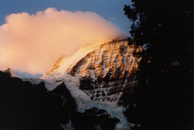
[Hide Photo] The Emperor Face and North Face of Mt. Robson, just above Berg Lake. This isn't the greatest scan. If someone posts a better image of the same face, or I get this rescanned, I'll remove this one.…
[Hide Photo] Joffre Formation looking mighty fine. Beautiful hike and some crags at the top
[Hide Photo] The South Face of Mt Waddington, June 2000.
[Hide Photo] The Sky Pilot Group from the Chief. Can someone clarify for me which peak is which?
[Hide Photo] Looking up at the Joffre formation from the Joffre Lakes parking lot, April 2004. Hopefully someone will post some information about the routes in this area soon!
[Hide Photo] Mount Jancowski area of the Boundary Ranges north of Stewart
[Hide Photo] Hagwilget Peak above the Hazeltons, with the classic north arete, comparable to the NW Ridge of Sir Donald (though technically harder), dropping towards the camera
[Hide Photo] Northern Cariboo Mountains near Mt Halvorson
The Blarney Stone is only eight kilometer outside British Columbia. I added it to create more artistic balance for the map. Not much else up in northern BC to interest rock climbers.
Also, the American Alpine Journal reported a different name in 2013. Neither the 2013 party nor the locals in Haines have actually climbed it. However, the name Blarney Stone has used by Alaskan climbers for about three decades. Yes, I am both correcting the AAJ (sorry) and giving away highly classified information to my fellow dreamers (unclimbed wall on an unclimbed mountain).
Sep 23, 2011
[Hide Comment] Not to contradict Peter Spindloe (who, as you may note, lives NORTH of Vancouver) regarding flying into Vancouver and exploring British Columbia from there, but save yourself a lot headache and bother by avoiding Vancouver, BC altogether. Fly into Bellingham, WA, fill up your gas tank at Costco, and take Hwy. 1 east around Vancover. Vancouver is congested, there are "red light" cameras everywhere, and the citizens are rude (sorry, not all, just too many). We loved BC and everyone outside of Vancouver was helpful and friendly. Join the Access Society of BC and the Squamish Access Society. These great organizations help to keep our crags open to climbers!
Jul 23, 2013


 Connect with Facebook


Golden, CO
The Blarney Stone is only eight kilometer outside British Columbia. I added it to create more artistic balance for the map. Not much else up in northern BC to interest rock climbers.
Also, the American Alpine Journal reported a different name in 2013. Neither the 2013 party nor the locals in Haines have actually climbed it. However, the name Blarney Stone has used by Alaskan climbers for about three decades. Yes, I am both correcting the AAJ (sorry) and giving away highly classified information to my fellow dreamers (unclimbed wall on an unclimbed mountain). Sep 23, 2011
Small Town, USA